Sentinel Overview
Leaf's service uses Sentinel-2 data which has the highest resolution publicly available and revisits each field every 3 to 5 days.
We generate a total of 25 images for each intersected field: a GeoTiff for each band from Sentinel and processed RGB, NDVI, NDRE and Multiband images.
The following table shows all the images with its resolutions and types: (TIFs are EPSG:4326, PNGs are EPSG:3857).
| Name | Resolution | Type | Projection |
|---|---|---|---|
| NDVI.png | NULL | png NDVI | EPSG:3857 |
| NDRE.png | NULL | png NDRE | EPSG:3857 |
| RGB.png | NULL | png RGB | EPSG:3857 |
| multi_band.tif | 10 | multi band | EPSG:4326 |
| NDVI.tif | 10 | tif raw NDVI values | EPSG:4326 |
| NDVI_color.tif | 10 | tif colored NDVI | EPSG:4326 |
| NDRE.tif | 10 | tif raw NDRE values | EPSG:4326 |
| NDRE_color.tif | 10 | tif colored NDRE | EPSG:4326 |
| RGB.tif | 10 | tif RGB | EPSG:4326 |
| B01.tif | 60 meters | single band | EPSG:4326 |
| B02.tif | 10 | single band | EPSG:4326 |
| B03.tif | 10 | single band | EPSG:4326 |
| B04.tif | 10 | single band | EPSG:4326 |
| B05.tif | 20 | single band | EPSG:4326 |
| B06.tif | 20 | single band | EPSG:4326 |
| B07.tif | 20 | single band | EPSG:4326 |
| B08.tif | 10 | single band | EPSG:4326 |
| B8A.tif | 20 | single band | EPSG:4326 |
| B09.tif | 60 | single band | EPSG:4326 |
| B11.tif | 20 | single band | EPSG:4326 |
| B12.tif | 20 | single band | EPSG:4326 |
| NDVI_relative.png | NULL | png relative NDVI | EPSG:3857 |
| NDVI_absolute.png | NULL | png absolute NDVI | EPSG:3857 |
| NDRE_relative.png | NULL | png relative NDRE | EPSG:3857 |
| NDRE_absolute.png | NULL | png absolute NDRE | EPSG:3857 |
PNG files do not have resolution because they are scaled up by 800%.
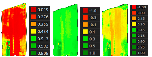
We generate a colorized NDVI_color.tif and NDRE_color.tif using a custom-built color ramp. See
the image below. If you prefer to use your own ramp, we recommend using NDVI.tif or NDRE.tif,
which is a pre calculated index file. You can import it into any GIS software,
like QGis, and use it as you please.
In addition, you will get the NDVI (i.e., we call them at Leaf as NDVI_relative.png, NDVI_absolute.png
and NDVI.png) cut for your area of interest. The NDVI relative uses the minimum and maximum of the image of that
date and, therefore, you would have a color scale to better visualize the differences of your harvest for that
specific moment, whereas, the NDVI absolute and NDVI, whose range goes from -1 to 1, you can make comparisons
on different dates, the difference between these files are the color ramp applied (i.e., in the NDVI all the values
below 0 are bright red while in the NDVI absolute the color ramp begins at -1 as the bright red and the value 1
as the bright green inteporlated in between). Same for NDRE.

We recommend using the option on the right (just ndvi.png).
Clouds
We use the cloud mask provided by Sentinel-2 to calculate the clouds coverage percentage.
See the Crop Monitoring API Reference for more information.