Field Boundary Management Endpoints
About
Here we list all the available endpoints from Leaf's Fields API. To call them easily, we recommend using Leaf's Postman collection.
All HTTP methods should be prepended by this service's endpoint:
There is a REST resources section if you want to check it out.
This service has the following endpoints available:
| Description | Endpoints |
|---|---|
| Get all fields | GET /fields |
| Get a field | GET /users/{id}/fields/{id} |
| Create a field | POST /users/{id}/fields |
| Update a field | PATCH /users/{id}/fields/{id} |
| Get all operation files of a field | GET /users/{leafUserId}/fields/{fieldId}/operations/files |
| Get an operation file of a field | GET /users/{leafUserId}/fields/{fieldId}/operations/files/{fileId} |
| Get fields by geometry | POST /users/{leafUserId}/fields/intersects |
| Get intersection of fields | POST /users/{id}/fields/intersect |
| Sync fields manually | POST /users/{id}/fields/sync |
| Enable a preview field | POST /users/{leafUserId}/fields/{id}/enableSync |
| Upload a Field to Provider | POST /users/{leaf_user_id}/fields/{field_id}/integration/{provider_name} |
| Delete a field | DELETE /users/{id}/fields/{id} |
| Get all boundaries from field | GET users/{leafUserId}/fields/{fieldId}/boundaries |
| Get a boundary from field | GET users/{leafUserId}/fields/{fieldId}/boundaries/{boundaryId} |
| Get active boundary from field | GET users/{leafUserId}/fields/{fieldId}/boundary |
| Update active boundary from field | PUT users/{leafUserId}/fields/{fieldId}/boundary |
| Get all farms | GET /farms |
| Get a farm | GET /users/{id}/farms/{id} |
| Create a farm | POST /users/{leafUserId}/farms |
| Update a farm | PUT /users/{leafUserId}/farms/{id} |
| Get all growers | GET /growers |
| Get a grower | GET /users/{leafUserId}/growers/{id} |
| Create a grower | POST /users/{leafUserId}/growers |
| Update a grower | PUT /users/{leafUserId}/growers/{id} |
Fields
Get all fields
GET /fields
Gets a paged list of Fields. It is possible to filter the results by passing some query parameters.
type, only matches fields with this type (string).farmId, only matches fields from this farmId (integer).provider, only matches fields from this provider (string).leafUserId, only matches fields from this user (string).page, an integer specifying the page being fetched.size, an integer specifying the size of the page (defaults to 20).
These last two parameters are used exclusively for paging through results.
Request examples
- cURL
- Python
- JavaScript
Response
Get a field
GET /users/{leafUserId}/fields/{id}
Gets a single Field by Leaf User.
Request examples
- cURL
- Python
- JavaScript
Response
A single Field as a JSON object.
Create a field
POST /users/{leafUserId}/fields
Creates a Field for the user leafUserId. A request body must be provided
containing the entry "geometry" object which need to have the properties "type" and "coordinates".
The geometry represents the boundaries of the Field being created as a GeoJSON geometry
("type" property must be a "MultiPolygon").
Consider that you can also set the id and name properties (both of them optional) in the request body. If no id is provided
an UUID will be generated and this property can not be updated.
Request body
Request examples
- cURL
- Python
- JavaScript
Response
Update a Field
PATCH /users/{leafUserId}/fields/{id}
tip
This is for manually created fields only. Provider created fields need to be updated via the Provider platform.
Update the Field by "id" for the user "leafUserId". The request body accepts updatable field properties like "name" to update the field name, "farmId" to update the related Farm of the Field and "geometry", which represents the boundaries of the
Field as a GeoJSON geometry (it must be a "MultiPolygon").
Request body
Request examples
- cURL
- Python
- JavaScript
Response
A Field as a JSON object.
Get all operation files of a field
GET /users/{leafUserId}/fields/{fieldId}/operations/files
Gets a paged list of all operation files of the Field and Leaf User specified in the URL.
It is possible to filter the results by passing some query parameters. They are listed below.
| Parameter (to filter by) | Type | Description |
|---|---|---|
| operationType | String "harvested", "planted", "applied" or "other" | retrieve operations of given type |
| provider | String "CNHI", "JohnDeere", "Trimble" or "ClimateFieldView" | retrieve operations of given provider |
| origin | String "provider", "automerged", "merged" or "uploaded" | retrieve operations of given origin |
| crop | String name of the crop, like "corn" or "soybeans". Entire crop list available here | retrieve operations with this crop. |
| startTime | ISO 8601 datetime format | retrieve operations that started after this date |
| endTime | ISO 8601 datetime format | retrieve operations that ended before this date |
You can also pass some parameters used exclusively for paging through results. They are:
page, an integer specifying the page being fetched (default is 0)size, an integer specifying the size of the page (default is 20, max is 100)
Request examples
- cURL
- Python
- JavaScript
Response
Get an operation file of a field
GET /users/{leafUserId}/fields/{fieldId}/operations/files/{fileId}
Gets a single Operation File of a field by its id.
Request examples
- cURL
- Python
- JavaScript
Response
Get Fields by geometry
POST /users/{leafUserId}/fields/intersects
Gets a list of fields that intersect with the GeoJSON geometry ("type" property must be a "MultiPolygon") sent in
the request body. The minimum intersection percentage is given by
intersectionThreshold and can range from 0.01% to 100%, its default value is 0.01.

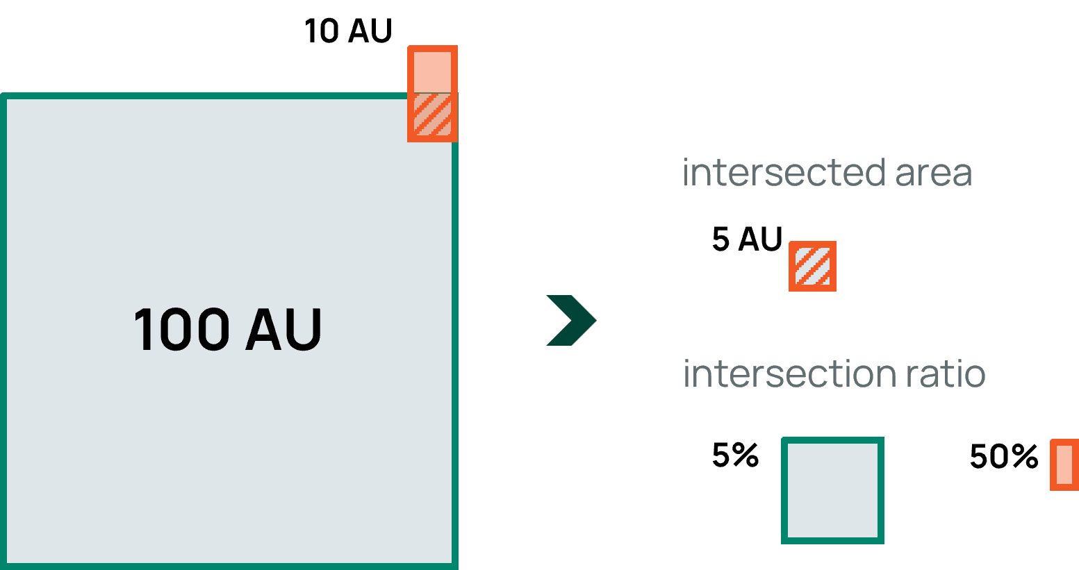
The intersectionThreshold can be compared with the "intersection by field" ratio or the "intersection by geometry" ratio. Whichever is satisfied first.
Here we have a sample for a field with 100 area unit and a geometry with 10 area unit:

So, in this case, if the intersectionThreshold were 3, then the condition would be satisfied and the field would be returned, but if the value was greater than 50, then it would not satisfy the condition, as 50% is the highest intersection value:
| intersectionThreshold (%) | satisfied |
|---|---|
| 3 | ✅ |
| 5 | ✅ |
| 37 | ✅ |
| 50 | ✅ |
| 75 | ❌ |
| 100 | ❌ |
Request body
Request examples
- cURL
- Python
- JavaScript
Response
Get intersection of fields
POST /users/{id}/fields/intersect
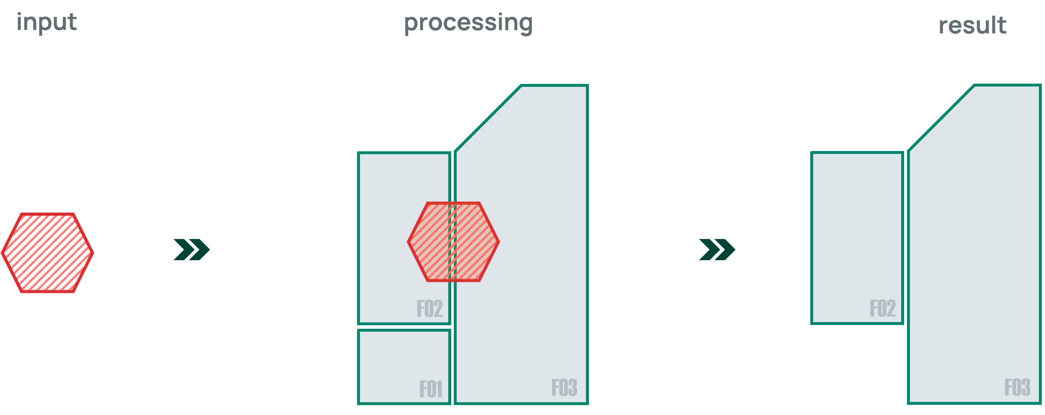
Gets a GeoJSON geometry ("type" property must be a "MultiPolygon") corresponding to the intersection of the Fields
specified by the given id's. Such Field id's goes in a list, in the request body.
Request body
Request examples
- cURL
- Python
- JavaScript
Response
Sync fields manually
POST /users/{leafUserId}/fields/sync
tip
This endpoint should be used to fetch field data when this fieldsAutoSync configuration is disabled.
Schedules a synchronization to fetch Field Boundaries data from the providers.
Request examples
- cURL
- Python
- JavaScript
Enable a preview field
POST /users/{leafUserId}/fields/{id}/enableSync
tip
This endpoint should be used to fetch data when the customDataSync configuration is enabled.
It will remove the field from the PREVIEW mode making it ready for be fetched in the next synchonization. The status will change to WAITING.
Request examples
- cURL
- Python
- JavaScript
tip
Fields can be set to synchronize at the grower level using the enable preview fields by growers endpoint.
Upload a Field to Provider
POST /users/{leaf_user_id}/fields/{field_id}/integration/{provider_name}
Upload a field boundary a provider. The field must be available on the Leaf API first (manually created or fetched from a provider).
provider_name: the name of the provider that will receive the field boundary. The supported providers areJohnDeereorClimateFieldView.- if the
provider_nameisJohnDeereit will be necessary to add theorganizationIdas a parameter:?organizationId={organization_value}
Request examples
- cURL
- Python
- JavaScript
Response
Warning
To avoid recursive synchronizations, it is not possible to send a field to the same provider from which it was fetched.
Delete a field
DELETE /users/{id}/fields/{id}
Deletes the field with the given id.
tip
Fields created by a provider cannot be deleted on Leaf side.
Boundaries
Get all boundaries from field
GET /users/{leafUserId}/fields/{fieldId}/boundaries
Gets a list of boundaries from a field.
Request examples
- cURL
- Python
- JavaScript
Response
A list of Boundary as a JSON object.
Get a boundary from field
GET /users/{leafUserId}/fields/{fieldId}/boundaries/{boundaryId}
Gets a single Boundary from a field by its id.
Request examples
- cURL
- Python
- JavaScript
Response
A single Boundary as a JSON object.
Request examples
Get active boundary from field
GET /users/{leafUserId}/fields/{fieldId}/boundary
Gets the active Boundary from a field.
- cURL
- Python
- JavaScript
Response
A single Boundary as a JSON object.
Update active boundary from field
PUT /users/{leafUserId}/fields/{fieldId}/boundary
Updates the active boundary of field fieldId. The previous active boundary is not deleted, but set as inactive.
Request body
Request examples
- cURL
- Python
- JavaScript
Response
Farms
Get all farms
GET /farms
Gets a paged list of all farms. It is possible to pass some query parameters.
growerId, only matches Farms from this growerId (integer)provider, only matches Farms from this provider (string)leafUserId, only matches Farms from this Leaf User (UUID)page, an integer specifying the page being fetchedsize, an integer specifying the size of the page (defaults to 20)
The parameters are used exclusively for paging through results.
Request examples
- cURL
- Python
- JavaScript
Response
Get a farm
GET /users/{leafUserId}/farms/{id}
Gets a single farm by its id from the user leafUserId.
Request examples
- cURL
- Python
- JavaScript
Response
A single Farm as a JSON object.
Create a farm
POST /users/{leafUserId}/farms
Creates a farm for the user leafUserId. It's possible to pass both the farmName and the growerId on the body of
the request.
Request body
Request examples
- cURL
- Python
- JavaScript
Response
A single Farm as a JSON object.
Update a farm
PUT /users/{leafUserId}/farms/{id}
Updates the farm with id id for the user leafUserId. It's possible to pass both the farmName and the growerId
on the body of the request.
Request body
Request examples
- cURL
- Python
- JavaScript
Response
A single Farm as a JSON object.
Grower
Get all growers
GET /growers
Gets a paged list of all growers. Use the following parameters for paging through results.
provider, only matches Growers from this provider (string)leafUserId, only matches Growers from this Leaf User (UUID)page, an integer specifying the page being fetchedsize, an integer specifying the size of the page (defaults to 20)
Request examples
- cURL
- Python
- JavaScript
Response
A list of Grower as a JSON object.
Get a grower
GET /users/{leafUserId}/growers/{id}
Gets a single grower by its id from the user leafUserId.
Request examples
- cURL
- Python
- JavaScript
Response
A single Grower as a JSON object.
Note
In our system, Growers are equivalent to John Deere Client. That been said, the
attribute name comes directly from the Client's name for growers with John Deere as provider.
Create a grower
POST /users/{leafUserId}/growers
Creates a grower for the user leafUserId. It's possible to pass name on the body of the request.
Request body
Request examples
- cURL
- Python
- JavaScript
Response
A single Grower as a JSON object.
Update a grower
PUT /users/{leafUserId}/growers/{id}
Updates the grower with id id for the user leafUserId. It's possible to pass only the name on the body of the request.
Request body
Request examples
- cURL
- Python
- JavaScript
Response
A single Grower as a JSON object.
Enable preview fields by grower
POST /growers/enableSync
tip
This endpoint should be used to fetch data when the customDataSync configuration is enabled.
It will remove the indicated growers' fields from PREVIEW mode leaving them ready to be fetched immediately after the request. The status will change to WAITING. It accepts a list of Leaf grower IDs.
Request examples
- cURL
- Python
- JavaScript
REST Resources
See below the REST resources and their endpoints.
Field Resource
A field might have one or neither of the following keys:
- a "mergedFieldId" key or
- a "sources" key
A Field will only have one of the previous keys if it is either a field that has been merged with other one(s) or if it is a result of a merge. Leaf merges fields that have any sort of overlap. This makes it easier for you to query operations from a field by querying by the merged field. Because a field might exist in multiple providers, Leaf detects that and creates a single field that you can query for - and you can still query by the individual fields too.
geometry and area are deprecated keys that contains the geometry of the active boundary and its area, respectively.
Preview mode
If the customDataSync configuration is enabled, the field will be fetched from the providers in the PREVIEW mode. A Field in PREVIEW mode has almost all properties except the geometry so that no boundaries will be available.
Those Fields will still be listed in the field endpoints, allowing the custom synchronization of the resources available in the providers. To fetch a Field completely, it is necessary to remove it from the PREVIEW mode, sending it in the enable a preview field.
After the change request, the field(s) will be marked as WAITING to be fetched completely in the next synchronization window and then, when it happens, the status will change to PROCESSED.
Field operations
In PREVIEW mode, the operation files associated with the fields on the provider side will also not be fetched and will only be available after the field sync request. Since not all providers support this relationship, it will only be reflected in John Deere and Climate FieldView files. For other providers, all files will be fetched normally, regardless of the configuration.
| Description | Endpoints |
|---|---|
| Get all fields | GET /fields |
| Get a field | GET /users/{id}/fields/{id} |
| Create a field | POST /users/{id}/fields |
| Get fields by geometry | POST /fields/query/intersects |
| Get intersection of fields | POST /users/{id}/fields/intersect |
| Sync fields manually | POST /users/{id}/fields/sync |
| Delete a field | DELETE /users/{id}/fields/{id} |
Boundary Resource
Every Field at Leaf can have 0 or many boundaries. Fields created via Leaf's endpoints must have at least one boundary. Only one boundary may be active, the others are inactive boundaries. Boundaries cannot be deleted or have its geometry updated. Every update generates a new Boundary, and Leaf keeps a history of all seen Boundaries.
Each boundary has a status and providerStatus.
status- Represents the current status of the boundary:ACTIVE- If the boundary was created at Leaf, it is the active boundary. If it is from a provider, this boundary exists at the provider and is the active boundary there.INACTIVE- If the boundary was created at Leaf, it is an inactive boundary. If it is from a provider, this boundary exists at the provider and is inactive there.OUTDATED_ON_PROVIDER- The boundary is from a provider. The boundary once existed on the provider exactly as it is in that boundary, but it was edited (e.g. has a new geometry but the same provider boundary id).DELETED_ON_PROVIDER- The boundary is from a provider. The boundary once existed on the provider, but it was deleted. The user won't find that boundary in the provider.
providerStatus- Is the status of the boundary on the provider.ACTIVE- The boundary is the active boundary in the provider.INACTIVE- The boundary is inactive in the provider.
providerStatus, just like the geometry, is a static attribute. In case this attribute is changed at the provider, the boundary's status is updated and a new boundary is created with the updated providerStatus in order to maintain history.
The geometry may be invalidly registered with the provider, more information in Troubleshooting.
| Description | Endpoints |
|---|---|
| Get all boundaries from field | GET users/{leafUserId}/fields/{fieldId}/boundaries |
| Get a boundary from field | GET users/{leafUserId}/fields/{fieldId}/boundaries/{boundaryId} |
| Get active boundary from field | GET users/{leafUserId}/fields/{fieldId}/boundary |
| Update active boundary from field | PUT users/{leafUserId}/fields/{fieldId}/boundary |
Operation Resource
| Description | Endpoints |
|---|---|
| Get all operations of a field (deprecated) | GET /users/{leafUserId}/fields/{fieldId}/operations |
| Get all operations of a field | GET /users/{leafUserId}/fields/{fieldId}/operations/files |
| Get an operation of a field (deprecated) | GET /users/{leafUserId}/fields/{fieldId}/operations/{fileId} |
| Get an operation of a field | GET /users/{leafUserId}/fields/{fieldId}/operations/files/{fileId} |
Farm Resource
| Description | Endpoints |
|---|---|
| Get all farms | GET /farms |
| Get a farm | GET /users/{id}/farms/{id} |
| Create a farm | POST /users/{leafUserId}/farms |
| Update a farm | PUT /users/{leafUserId}/farms/{id} |
Grower Resource
If there is a name available for the grower so the name property will be returned as well.
| Description | Endpoints |
|---|---|
| Get all growers | GET /growers |
| Get a grower | GET /growers/{id} |
| Create a grower | POST /users/{leafUserId}/growers |
| Update a grower | PUT /users/{leafUserId}/growers/{id} |
Troubleshooting
Currently, Leaf gets the field boundary data as available from the provider, so in some cases there may be fields without boundaries or with invalid boundaries, identified with one of the values below:
| Validity values |
|---|
| VALID |
| REPEATED_POINT |
| HOLE_OUTSIDE_SHELL |
| NESTED_HOLES |
| DISCONNECTED_INTERIOR |
| SELF_INTERSECTION |
| RING_SELF_INTERSECTION |
| NESTED_SHELLS |
| DUPLICATE_RINGS |
| TOO_FEW_POINTS |
| INVALID_COORDINATE |
| RING_NOT_CLOSED |
| NOT_ALLOWED_GEOMETRY_TYPE |
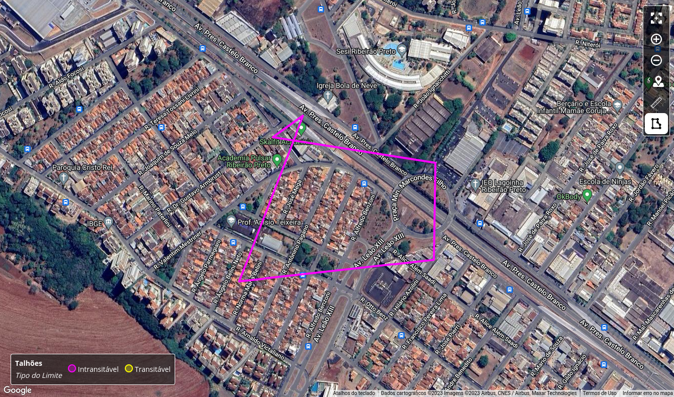
Here is an example of a geometry registered as invalid due to a SELF_INTERSECTION.
This is what this invalid type of geometry looks like from the provider side:

Automatic geometry fix
There is a configuration available to fix the invalid geometry that Leaf fetches from the provider.
When enabled, Leaf will try to fix the geometry. If the fix is successful, then the invalid boundary will be disabled (available as a historical boundary) and the new one will be available as the main boundary with the property "fixStatus": "FIXED"
This behavior only applies to Fields obtained from providers, as validation prevents Fields from being created manually with invalid geometries.
Warning
Note that this is an automatic procedure and that the corrected geometry may present small differences in relation to the original, such as an increase or decrease in area.